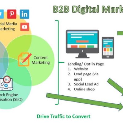
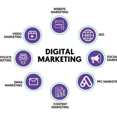
Technology Education Know-How

Helping Teachers Teach with Technology

  • Feeds

  • Pages

  • Greg's Flickr

    www.flickr.com
12
May

YouTube and TeacherTube on your iPod???

This week’s post was prodded by a question asked in my PLN (personal learning network) last week. 

As time goes by, I think, we’ll be seeing more iPod use in the classroom.  The good part about that is that there is a lot of already generated content that you can use, borrow or beg from.  You can find great educational materials on YouTube, teachertube and other online streaming sources.  Don’t you wish you could get some of that material onto your iPods? 

Well, today I’m going to give you several tools that you can use to get the job done.

First is: http://www.techtracker.info/  You just simply past the URL of the streaming video into the line and then download. 

Second is: http://get2pc.com/  Past the URL and download your new file.  After download you’ll need to add “.flv” to the end of your file for it to work.

Thirdly is: http://keepvid.com/  Same as above, copy and paste then download your new video.

There are more, but these are the ones that I’ve used and have worked.

Now all you have to do is import your video into your iTunes and send it to your iPod. 

(Note: Do not use copyrighted material.  You could get in trouble.)

05
May

Plan a Vacation to Teach Math Skills

This week I was talking to a friend about going on their vacation this summer.  As a teacher I had two things going in my head.  One was, “I need a vacation.”  The other thought was, “How can I turn this into a real world learning experience for our students?”

Of course, http://www.priceline.com/ came to my mind, but there are other sites as well that can be used. 

Have your students create a dream vacation.  They will need to plan for travel to and from the departing location, the plane fair, cruise, activities, hotel or condo, transportation while on location, food etc.  You can make this activity as extensive as you’d like.  This activity will help them review the math skills that you have already given them while applying them to real world situations. 

To expand the learning experience I would have my students:

1.       Budget  (money, charts and graphs)

2.       Plan an Itinerary Schedule (time line development, elapsed time, scheduling, and critical thinking)

3.       Map out events (maps)

4.       Use checklists to make sure they have thought of everything for their trip. (Google, travel checklist and you’ll get tons of them.)

5.       Have them write about their trip planning learning experience.

To extend their learning experiences have them break into travel groups and plan their entire vacation on a wiki! 

Enjoy and leave a comment letting me know how you plan to use this in your classroom. 

28
Apr

3 Classroom Lessons for Using Gas Prices to Teach Math, Writing, Social Studies, and Technology

This morning on Yahoo! News another headline reads “Gas.”   Later this morning as the headlines rotated out another one read “Gas.”  Yes, we are facing “Gas” issues like never before.  So, why not turn this into a learning activity for our students.  Our children will face things that we have never faced before, and our job is to prepare them.  So, this Tech Tip will incorporate Math, Writing, Current Events, Maps and Technology.    

The goal here is that we tap into the higher order thinking skills of every student and allow them an opportunity to problem solve a real world event. 

Note: Teachers should not use this to promote any political agenda; you can find yourself in hot water over that.  This is just an exercise for learning.

Note: If you are reading this and are in another city, state or country there are alternative sites that you can use to gather the same data for your location. 

Exercise 1:

This web site http://www.eia.doe.gov/oil_gas/petroleum/data_publications/wrgp/mogas_history.html  produces a Microsoft Excel Spreadsheet with a price history of gas prices by region, state, or even some cities.  From these spreadsheets you can create charts and graphs showing changes, have students calculate differences between time periods and even calculate percentages in change over time. 

You can have your students present his/her findings to the class in a power point, video, printed graphs and a written report. 

            The teacher can discuss issues as they come up.  (No Political Agendas!)

Exercise 2:

Now that students can know the importance of and can physically see from the above presentations that the price of Gas is a real issue, have them do a little problem solving.  Have the students go to http://www.autobytel.com/content/research/top10/index.cfm/action/mileage/vehicleclass/all/listtype/3  to make an automobile selection based on their newly found information.  Encourage your students to select cars that would be suitable or comparable for their current families.  (ie. If their mom drives a van now have the select a type of van.  If they drive a truck have them select a type of truck.) 

Their goal is to select a vehicle that would save them money as well as suit their needs.  Have them research the different car types, gas mileage, and feasibility.  They can sort the cars by all, compact, convertibles, luxury, passenger, pickups, sport utility, sports, vans and wagons.  (I think I want the Honda Civic, does it have enough room for my kids?)

Have the students report back with their selection.  They should make a presentation of their top 3 choices with a conclusion as to why they selected their top choice.  How will this car impact gas prices?  How much money will they save by getting this car?  Does the price of the car off set the price of gas?

If you want to make this an extra challenge  give them a car price budget and a weekly gas budget.  They should have a select number of miles that they have to calculate to get to and from work(school).

ie: Less than $20,000 for a car.  Weekly gas allotment is $40.  They must drive 20miles one way to work.  You’ll need to give them a list of web sites from local dealers to get the prices on the cars.


Exercise 3:  The Big Challenge

 Using Google Maps or Yahoo! Maps along with http://www.austingasprices.com/  or http://www.gasbuddy.com/ for those not in the Austin area, to calculate mileage to determine if it would be worth it to drive out of your way to the cheapest gas prices locations. 

Students will need to know:

1.      gas mileage of car (from exercise 2)

2.      price of gas (exercise 3 links)

3.      mileage to lowest priced gas station (Google Maps or Yahoo! Maps)

4.      price of gas at the gas station near your school (you’ll need to provide this)

5.      location (mileage and map) of home and school (work) (Google Maps or Yahoo! Maps)

Have the students report as to whether or not it’s worth the extra drive.  Will they save money or not?

Closing:

As always, these activities can be extended, shortened or changed.  You are only limited by your imagination as to how this can be used in your classroom.  For higher grade levels you can turn them loose with the idea and see what they come up with.  I think we would all be shocked! 

My generation kinda grew up not being very concerned with the environment or economy at all, but today’s generation seems to be more involved with trying to solve issues than we ever where. 

If you use these ideas leave a comment and let me know how it went, or if you have other ideas please share!


22
Apr

Amazing Space Activities

This week I would like to introduce you to Amazing Space at http://amazing-space.stsci.edu/

Amazing Space has lots of amazing tools and resources for teaching about the solar system, space and observation tools.  Here you will find videos, diagrams, images, lesson plans, and student activities that involve exploration, history and new found knowledge.   If nothing else this is a great place for your students to start their research, and I’m sure you’ll find some useful tools and information as well, I know I did. 

I enjoyed getting to see images from the Hubble Telescope like this one of the Whirlpool Galaxy and the Companion Galaxy. 


Wow! Along with that image comes a complete lesson plan.  Click here for the complete lesson plan.     

I hope that you enjoy exploring this site of exploration!  Leave a comment giving suggestions of how you used it, plan to use it, or other related sites of interest. 

17
Apr

Captivating Ideas for Writing with Cartoons

After blogging about this before I’m sure you know by now that I’m a big advocate for using cartoons to get students writing.  So, here we go again with more detail and more ideas.

http://www.makebeliefscomix.com/  provides an easy tool for creating short comic strips.  You can choose to have a 2, 3, or 4 window comic strip.  Students can email or print it out for their teacher.

I made this cartoon with this new tool.  short, quick, and easy

Cartoon 

Why Comic Strips:

1.       Comic strips are about good writing not good pictures. 

2.       It helps them hewn their skills of knowing their audience. 

3.       It helps them focus on important content and story line.  (key story elements)

4.       It gives them a strategy to order the sequence of events. (beginning, middle, and end)

5.       Students will learn how to infer ideas to their readers.

6.       The student must know the Plot, Scene, and Characters to write a good comic strip.

7.       Students will use “voice” as their character develops. 

8.       Students will learn how to write dialogue correctly.  (bubbles mean quotation marks)

9.       It makes the student think outside the box. (no pun intended)

10.   While using their higher order thinking skills they will learn to analyze and think critically.

Strategies for Using Comic Strips:

1.       Have a collection of quality comic strips for your students to analyze. 

2.       Discuss character development. Who? What were they like? Why are they that way? Look at the “voice” of the character. What is their personality like?

3.       Discuss the story line.  Does it have a plot?  What is the point?  Did it communicate?

4.       Discuss the setting.  Where? When?

5.       Have students create a scrapbook of their favorite comics.

a.       They should collect different styles. Funny, Serious, Political, etc.

b.      Have them do some research about the history of the comic they like.

6.       Start with a sequence of pictures or drawings and have the student fill in the script.  This takes the focus off of the drawing and puts it on the content.

7.       Have the students stick with their character for several comics.  This will give them a chance to develop the characters personality.

8.       Keep the comics short.  This is not a comic book project.  At least not yet.

9.       Have the students use their characters and write a full length story based on their comic strips.  You’ll be surprised as to how they turn out.


After reading this post, take a look at these TEKS and just imagine how you can use comic strips to teach these.  If you aren’t in Texas and you are reading this take a look at your state’s writing standards.


If you have other ideas please leave a comment.  I’ll add it to the list.  This list is not exhaustive nor is it the only way to teach writing.  It’s only one of many strategies that I have used. 


After writing this post I felt like I may need some supporting documentation, so I turned to good ol Google.  Here are some links to what I found. 

http://www.readwritethink.org/materials/comic/index.html

http://www.readwritethink.org/lessons/lesson_view.asp?id=188

http://www.techedknow.com/?p=12

http://www.glc.k12.ga.us/BuilderV03/LPTools/LPShared/lpdisplay.asp?LPID=73715

Wish I had this when I needed it!  It’s full of templates, ideas, samples, tools, and a rubric.

http://www.flummery.com/teaching/


Here is a Comic Strip Template from Microsoft. 

http://www.microsoft.com/downloads/details.aspx?FamilyID=bd39a11b-2a5d-470d-8327-311e39813c2e&displaylang=en&Hash=%2fMIXbN0zA9zXJXnYWkNdE5WHM4SEbCJtZYrzOoP3uFpUB1HMPoNEMDJEwAfV70vJkA9imGg6PvgoSL%2b4lx8zZw%3d%3d

14
Apr

Tracking of the Torch for Education

One of the things that makes Google Earth so fantastic for Education is it’s popularity.  People are always putting new features into Google Earth that help teaching more fun and authentic for our students.

The newest feature I want to mention is the Map Tracking the Olympic Torch.  http://maps.google.com/help/maps/torchrelay/  You’ll be able to see pictures of prominent places around the world as you track the torch.  I’m sure your students would find this interesting. 

To use in your Google earth follow the link above and thin click the blue link below the map that says, “Track the Torch in Google Earth.”


Extend the Learning Ideas:

Social Studies:

* If you are teaching maps, Google earth provides the coordinances that you can use to teach latitude and longitude.  

* Students can learn about other cultures.  Do you have any students that are from the cities that the torch will be visiting?  Today the torch is in the city of Muscat.  According the information found in Google Earth Muscat is the capital and largest city of the Sultanate of Oman.  The pictures of the other cultures are phenomenal that you’ll find as you track the torch.

Math:

* You can use the maps and calculate the distance that the torch has traveled and will travel. 

Writing:

* You could have your students write about their favorite Olympic events, countries that will be participating in the Olympics, or even differences that they find between cultures. 


The integration possibilities are endless as you open your minds to this great tool!  Leave a comment letting me and others know how you used the Tracking of the Torch for Education! 

13
Apr

FlashEarth = Googe + Yahoo! + Microsoft VE Maps

This week I’m introducing www.FlashEarth.com to my teachers.  FlashEarth is a tool that combines Google Maps, Yahoo Maps, and Microsoft VE along with a wide view of NASA satellite images.  Before when teaching Maps you were limited to working with one map view or having the hassle of going between the different mapping services.  Now you have access to one page that has all 4 services on it (limited). 


You will find that each service offers a different view and even a different seasonal view of the same location.  I’ve searched all over Texas in the last few days using the FlashEarth web page and I have grown to like Microsoft’s VE view.  For my area it provides the clearest and closest pictures.  As a mater of fact, it was kind of concerning as to how clear some things were. 


In the bottom right hand of the page you’ll find your search box.  Just simply type in the address or general location and you are on your way.  Switch back and forth between the mapping services to find the preferred map of your searched area.  It’s that easy!


There are some features missing that you would normally find on the service providers real page, so I would use this to get quick details and image quality to determine which service I wanted to use in my classroom.

Here’s what I found:


Google Maps: The pictures in my area were old and out of date.  You could get fairly close and get reasonable details and resolution.  Google needs to update their images for the areas of the country that are under rapid change such as Austin, Dallas, and San Antonio.  In FlashEarth (Google) you will be missing the map view because it only provides the satellite view.  From what I can tell about my area is that the images are about 5years old.


Yahoo Maps: The pictures in my area were newer than Google’s but still a bit out of date because of our rapid growth.  They are about 3 years old.  The details are not as good as the Google details and the distance is a little farther away.  Again only the satellite view was available.  I like the Yahoo Map service on the Yahoo page because they often have location details that the other two don’t, but the satellite view has much to be desired for me.


Microsoft VE: The pictures were the most detailed of all for my area.  The quality of imagery was even good for non-populated areas.  Microsoft services (on FlashEarth) was the only one that provided street details.  It labeled streets and cities making it easy for you to find where you were.  You could get closer with great visibility  to most locations.


NASA View: This was a nice cool feature to have with all the other maps.  It is updated daily showing you the flow of clouds over earth.  It is spliced together making the view flat.  There is no close details using this service.  This can only be used at a great distance away, but it is one of my favorite features of FlashEarth. 


You may find each service image quality different in your area, and remember many of the features that each individual service (outside of FlashEarth) offers are great tools for education.  So, be sure and check those features out on their web pages.  I think you will find some great tools for your classroom!  Check them out and leave a post telling the rest of us what you think. 


09
Apr

www.realworldmath.org Launches This Week!

This morning as I was reading a blog post I ended up linked to www.realworldmath.org.  RWM is a new website that “is designed for educators who wish to extend the concepts of the math curriculum beyond the pages of the text.”  Thomas Petra, creator of realworldmath.org, uses Google Earth to teach Math concepts, and he is sharing his ideas and lessons with us.  He has also opened up the doors to allow fellow teachers to contribute to the site with other Google Earth Math Lessons.  I really thing Thomas is on to something here.  You’ll find under the Lessons page 4 categories of lessons, and on the updates page he has two more categories.  So, be sure to check out the whole site! 

This site is only one day old, but I expect to see lots of great things coming from this!  Get the word out by sharing with your teachers.  We can all use new ideas for teaching Math.

If you don’t find a lesson here that you can use, I’m sure you’ll get ideas for your classroom. 


01
Apr

Google’s History Video Archives

This weeks Tech Tip is for the Social Studies Teacher.  You will find that Google has partnered with the NARA to digitize 104 films of history.  You will find them on the Google page http://video.google.com/nara.html

I took a look at one of the news reels from D-Day and it was amazing looking at this time in history as it happened.Teachers can use this public domain data by allowing students to view the content as it was in history.  How powerful could this be?! 

You will find clips from NASA, War News Reels, and the Department of Interior.  The Department of Interior video about the Tennessee Valley Authority in 1936 was awesome!  I loved seeing the old machinery working as I gained a new appreciation for the advancement of Technology today. 

I think you will find this a great tool for teaching history and giving students an opportunity to view history through the eyes of the people that lived it.  

Note: I do advise; preview each clip before you show it to your students.  Some things just shouldn’t be seen by certain age groups. 

25
Mar

NetTrekker

This weeks Tech Tip is NetTrekker.  NetTrekker is a resource that our district provides for our teachers, staff and students.  We use NetTrekker because it is a safe way to insure that our students get good, reliable and safe information.  With NetTrekker, if you login through your schools library web page, your searches will be filtered through the state TEKS Standards.  Meaning - your search results will have true academic purposefulness. 

Here is a blurb from their web page, “Each resource is carefully selected by educators to ensure it is safe, age-appropriate and 100% academically relevant.”

I did a search on “Vitamins” and I learned something myself.  Did you know that lots of vitamin D can cause you to lose weight?  Here’s the catch, you lose the wait because too much Vitamin D can cause you to vomit.  Not the right way to loses wait!!  Anyway, I digress, so back on track.

Take the time to introduce NetTrekker to your students this week.  It is a resource that our district provides for you to keep your kids safe and on the right track with their research.  It’s an awesome tool!  The listings of uses of NetTrekker are too many to list here.  Take a look for yourself!

You can get to NetTrekker from your school’s library web page.  If you’re reading this post and you are not a part of RoundRock ISD schools, you can try NetTrekker free at http://www.nettrekker.com/

Keep up the good teaching with technology!!!

Side Note: Most web pages have links to other web pages.  These other web pages may or may not be safe, so I suggest you still do active monitoring during your computer times.  Leaving your students un-attended during computer time is not a safe practice anytime!


© 2008 Technology Education Know-How | Entries (RSS) and Comments (RSS)

Design by Web4 Sudoku - Powered By Wordpress